Teterboro Airport Airspace & Procedures
Technique for How to Fly the RUUDY 6
Please click on the following link to view this excellent guidance material written by our own Capt. Jim Dramis:
ILS Rwy 19 GS Perturbation
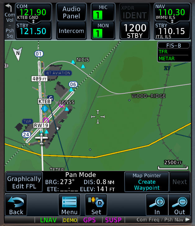
Teterboro’s unique geometry incorporates a GS antenna for Rwy 19 located just south of taxiway Q. The GS Critical Area therefore lies just to the north and incorporates portions of Taxiway Q, Runway 24 and Taxiway B. Per the AIM, Teterboro Tower is not required to protect the GS Critical Area unless the weather is below 800 and 2, or unless specifically requested to do so by a flight crew. During VMC and when Teterboro is on a southerly flow, aircraft taxiing northbound from Jet Aviation and First Aviation for departure on Runway 24 cross Q from west to east and impinge upon the GS Critical Area. The same phenomenon can occur when an aircraft departs Runway 24 or holds on Taxiway B between Runways 24 and 19. The resulting GS perturbation appears to have caused a number of aircraft to pitch up in an effort to track the momentarily compromised signal. These aircraft have been of various types and avionics suites. Because the perturbation occurs occasionally, is transient in nature, and affects aircraft during a busy phase of flight, the phenomenon has been underreported to ATC.
DOT Publishes Dr. Divya Chandra’s Report on NY & Multiple Airport Route Separation (MARS)
As you may recall, our June 16 TUG Meeting featured a presentation from Divya Chandra, PhD and Andrea Sparko, U.S. DOT Volpe National Transportation Systems Center, Principal Technical Advisor | Transportation Human Factors Division and Engineering Psychologist, introducing a DOT human factors study of flight operations in the NY area. They subsequently conducted a series of 1-hour “listening sessions with groups of 2-4 pilots, and many of you volunteered to participate.
Dr. Chandra and Andrea Sparko recently published this report, and sent the following announcement and expression of gratitude to TUG:
“We recently published our report with the data we gathered from you and other pilots who fly in the NY airspace. The pilot listening sessions were an important part of the larger project.
The report is available at:
FYI, one of our FAA sponsors passed this report on to a UK representative who found it helpful for his work on complexity of flight operations. We also sent it to FAA in Oklahoma City, where they are working on the safety analyses for Multiple Airport Route Separation. The report was also briefed to FAA and industry members of the PARC (Performance-based navigation aviation rulemaking committee, I believe). So it’s getting some good visibility.
Thanks again for helping us gather data from the NY pilots. The input was really enlightening.
Best,
Divya
Divya Chandra
Principal Technical Advisor | Transportation Human Factors Division (RVT-314)
617-494-3882 (office) | 617-999-3246 (cell) | [email protected]
U.S. DOT Volpe National Transportation Systems Center
55 Broadway. Cambridge, MA 02142 | Kendall Square”
KTEB RNAV(GPS) X Rwy 19
On July 1, the KTEB RNAV (GPS) X Rwy 19 became available as an alternative IAP designed to mitigate noise when Teterboro is operating on a southerly flow. For some additional background on the procedure’s inception, please click on the following link to see AIN’s article: https://www.ainonline.com/aviation-news/business-aviation/2021-06-24/teb-begin-runway-offset-arrivals-july
Note that NY TRACON has advised that, when KTEB is operating on a southerly flow, the RNAV (GPS) Y Rwy 19 straight-in approach will be the preferred procedure. However, subject to weather conditions, controller workload and traffic volume/complexity, the RNAV (GPS) X Rwy 19 offset approach will be made available upon pilot request. This procedure may even be advertised on ATIS as the approach in use, particularly during the hours 2200 – 0700.
Operators are advised that the newly published RNAV (GPS) X Rwy 19 approach incorporates some unique characteristics that warrant a thorough briefing: 13 degree offset final, LP (many avionics suites do not yet offer LP approach capability) and LNAV minima, relatively high MDA and visibility minima, a Visual Descent Point (VDP), and close proximity to the WABC-AM antenna tower.
Specifically, the ABC antenna tower is located 1.54 nm from the touchdown point. A crew following the procedure on the chart-specified 3 degree path will reach the Visual Descent Point (VDP), 2.6 nm from the runway threshold, at the LNAV MDA of 960’, placing the aircraft 267’ above and 1.06 nm NNW of the ABC antenna tower. The crew may at this point maneuver as necessary to be stabilized on final approach no later 500’.
We’ve compiled some change management best practices that operators may wish to consider in order to maintain the highest levels of safety as they prepare for this new procedure:
(1) All pilots will review the intricacies of this approach, including but not limited to the following: 13 degree offset final, LP and LNAV minima, approach modes to be utilized, airspeed and configuration targets, visual Descent Point (VDP), and proximity to the WABC-AM antenna tower.
(2) Each pilot will first fly the approach in daylight VMC conditions (left or right seat is sufficient) before requesting the approach at night.
(3) Pilots should not request this approach unless the weather is at least 2000’/3sm.
(4) Pilots will commence their turn to align with the runway at the VDP. Pilots wishing to commence this turn earlier must first coordinate with ATC.
(5) This procedure is intended to benefit the surrounding communities by mitigating aircraft noise exposure.
(6) If, in the judgement of the crew, executing this IAP is inadvisable due to a lack of crew familiarity, suboptimal weather, obstacle clearance considerations, fatigue or other adverse factor(s), the crew should declare unable and instead request to fly the RNAV (GPS) Y Rwy 19 or ILS Rwy 19 approach.
FAA, NBAA Secure New, Specialized Departure Options for Bizav Flights From NYC Area
July 8, 2021
Starting today, the FAA will begin implementing new routes specifically designed to assist business aircraft operators departing from New Jersey’s Teterboro Airport (TEB) and New York’s Westchester County Airport (HPN), both near New York City, during times of high traffic congestion or severe weather.
Developed with consideration of the performance profiles of turbine-powered business aircraft, the new “escape routes” will only be issued by ATC, with New York TRACON (N90) coordinating with tower controllers who will then verify that pilots are able to fly the assigned route.
The new routes are part of the FAA’s Northeast Corridor (NEC) initiatives under the NextGen Advisory Committee (NAC), upon which NBAA serves. Association President and CEO Ed Bolen personally emphasized the need for the new routes with FAA officials, in his position on the NAC.
Heidi Williams, NBAA director of air traffic services and infrastructure, explained how the new routes will be administered. “N90 will assign these escape routes when able to allow operators to get up and out of the northeast, versus sitting on the ground for excessive timeframes.”
Williams noted the new options for New York-area departures mark the culmination of a multi-year effort between the FAA and the association – a collaboration that remained a priority for both parties, even as the FAA faced a host of pandemic-related challenges.
“Although many programs and activities over the past 18 months were impacted by COVID-19, the FAA remained fully committed to realizing this important effort to reduce departure delays at New York-area facilities most often utilized by business aircraft operators,” she said.
However, Williams further emphasized flight crews must do their part to assist with the process when accepting one of the new departure routes.
“You must fly them as designed; don’t accept the clearance and then ask for direct after launching,” she said. “Operators must also consider their aircraft’s weight and performance parameters, as these routes may utilize steeper climb profiles than normal.”
The new routes will be published to the agency’s Operational Information System webpage Aug. 12. NBAA Air Traffic Services will assist in the rollout of the new routes from the FAA Air Traffic Control System Command Center.
The routes will be used on a limited basis, and a fair number of restrictions apply to their use. Pilots should not file these routes. Instead, NY TRACON will solicit their use.
The routes to join the west gate airways are:
| Q75 | ..GREKI..JUDDS..RONGE..PWL..BIZEX.Q75.BIGGY.. |
| J48 | ..GREKI..JUDDS..RONGE..PWL..BASYE.Q448.LANNA.. |
| J6 | ..GREKI..JUDDS..RONGE..PWL..BASYE.Q406.BWZ.J6. |
| Q480 | ..GREKI..JUDDS..RONGE..PWL..IGN.Q480. |
| Q42 | ..GREKI..JUDDS..RONGE..PWL..IGN.Q480.MIKYG.Q42. |
| J60 | ..GREKI..JUDDS..RONGE..PWL..IGN.Q480.CANDR.J60.DANNR |
| J64 | .GREKI..JUDDS..RONGE..PWL..IGN.Q480.CANDR.J60.DANNR..RAV.J64. |
New FAA National Airspace System (NAS) Status Web Link
The FAA has redesigned their Fly.FAA.Gov NAS Status web link in order to provide a more user-friendly and convenient access to FAA decision making products while improving user value. Users should note that they can now select a “map” view that will pictorially display NAS events in real time. To access this application go to https://nasstatus.faa.gov.
Reroutes Into TEB/MMU/CDW During Active Wilmington, DE (ILG) POTUS TFRs
Flight operators should file the routes as delineated in the following:
- Flights coming North to TEB/MMU/CDW click here.
- Flights coming South and West to TEB/MMU/CDW click here.
- Specific and most current details on these reroutes are available when they are active on the FAA Current Reroutes webpage which can be found at https://www.fly.faa.gov/ratreader/jsp/index.jsp
- Note: Crews should be aware that during these TFRs the JAIKE Arrival will not be available and the reroutes add significant time when coming into the NY Metro area from the south, crews should fuel plan accordingly.
Aircrew Guidance for ATC Zero Events in Oceanic and Class “A” Airspace
The following Oceanic ATC Zero and CONUS Class “A” Airspace planning and procedural guidance is courtesy of OPSGROUP.
Click here to view – Planning for “ATC Zero” events in Oceanic Airspace document.
Click here to view – ATC Zero in Class “A” Airspace document.
“30 West IP” has published an excellent handout describing the new Oceanic Contingency Procedures:
NBAA Article Describing New ICAO Doc 4444 Oceanic Contingency Procedures, Wake Turbulence Categories, and SLOP Rules, which go into effect Nov 5, 2020
New global oceanic traffic separation and contingency procedures developed by the International Civil Aviation Organization (ICAO), which go into effect Nov. 5, were the topic of the latest NBAA GO presentation.
The updated procedures – outlined in Amendment 9 to ICAO Document 4444, “Procedures for Air Navigation Air Traffic Management (PANS-ATM)” – were driven by a January 2016 incident in which a Challenger 604 business jet suffered a severe inflight upset while operating in Mumbai airspace.
“On a published route, they flew directly underneath an Airbus A380 flying in the opposite direction on the same route 1,000 feet above them,” explained presenter Mitch Launius, founder of 30 West IP. “The 604 encountered the wake vortices of the A380 and rotated four to five times before descending out of control for approximately 9,000 feet.” Although pilots were able to regain control of the Challenger and land successfully, several onboard suffered injuries and the airframe was declared unairworthy.
Among the new procedures is a new, “Super” wake turbulence category that effectively applies to just the A380. Amendment 9 also updates Strategic Lateral Offset Procedures (SLOP) intended to mitigate lateral overlap of aircraft flight tracks. The revised procedures allow pilots to implement SLOP in tenths of a mile up to 2 nautical miles to the right of the filed flight path, even when not operating on an assigned track.
“On a random route against the flow, so not going with tracks, your flight planners are still going to get you the [lowest] time route,” noted Steve Thorpe, director of training and standards at Merck. “If anyone else is on a random route going the same way, they likely could be right there with you in the same area.” Routes allowing SLOP may be found in aeronautical information publications, or AIPs, which are also linked in commonly-used flight planners from Jeppesen and ForeFlight.
Amendment 9 also includes harmonized global contingency procedures for aircraft unable to maintain flight along an assigned oceanic track when out of communication with ATC. The changes provide specific instructions for initial course deviation – at least 30 degrees left or right, dependent on surrounding traffic – and vertical and lateral offset distances.
While emphasizing the need to be familiar with the ICAO contingency revisions and to train for them, Launius noted such contingencies can largely be avoided thanks to the implementation of controller-pilot datalink communications allowing continuous text communications between aircraft and ATC.
“Most of the time we don’t need to execute contingency procedures, but we do need help,” Launius said. “Perhaps the temperature is too warm, and I need to descend [as] I can’t maintain altitude … or perhaps I need to deviate around a thunderstorm. There’s a lot of cases where I can receive a prior clearance, and that’s the ‘A’ plan.”
FAA Issues SAFOs re: ATC Closures in Terminal Airspace and Loss of ATC Services in Oceanic Airspace
SAFO 20012 re: ATC Closures in Terminal Airspace
SAFO 20011 re: Loss of ATC Services in Oceanic Airspace
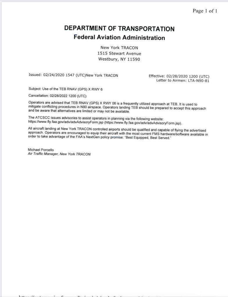
NY TRACON LETTER TO AIRMEN re: KTEB RNAV (GPS) X Rwy 6
Please see the following N90 LTA.
Note also when executing this approach that the Missed Approach Point is JEBUV, which is located 1.1 nm prior to the runway threshold on the 063 final approach course. Upon reaching JEBUV, the FMS will no longer provide lateral and vertical guidance to the runway.
Lessons Learned: Non-Precision Approaches
A business jet crew on arrival to KTEB prepared to fly the ILS Rwy 19. Upon retrieval of the most recent ATIS, however, they learned that the G/S was OTS. The crew then briefed the LOC Rwy 19 approach, and confirmed that the avionics were properly configured for the localizer only. Consistent with best practices for a stabilized approach, they planned to execute a Continuous Descent Final Approach (CDFA), and so calculated a Derived Decision Altitude (DDA) of 630’ (50’ above MDA). The crew used APP mode to capture the localizer and Path/Vertical Speed mode to initiate the descent. During the final approach segment, they learned that the preceding aircraft had executed a Missed Approach. At their DDA of 630’, the crew hadn’t visually acquired the runway environment, and similarly executed a Missed Approach. Pursuant to their interpretation of the published procedure, they began an immediate climbing right turn to a 205 heading, and noticed that the flight guidance was inconsistent with their lateral track. The FMS did not appear to have sequenced to the Missed Approach Segment as expected. Consequently, the crew manually flew the Missed Approach procedure. Once established on the published 278 course to MORNS, they manually sequenced the FMS direct to MORNS.
The crew then elected to conduct a second approach, but this time chose to perform a “Dive & Drive” as opposed to a CDFA. Prior to reaching the Missed Approach Point, they visually acquired the runway environment and made a normal descent to landing.
The crew subsequently forwarded the following observations, and requested comment:
– The missed approach point for this procedure is not co-located with the runway end.
– The FMS coding, however, takes you all the way to the runway end.
– “Dive & Drive” generated a successful result, whereas CDFA did not.
TUG forwarded the crew’s narrative to NBAA’s Access Committee for review and comment.
For reference, here is the FAA chart:
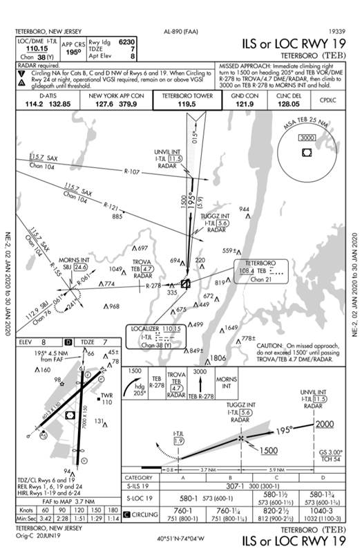
The review revealed that the FMS behaved correctly. However, the crew did not follow the published Missed Approach procedure. Upon reaching the DDA of 630’ on a CDFA Localizer only approach, they had not reached the published LOC Missed Approach Point of I-TJL 1.9D, 0.8 NM from the runway threshold as depicted in the profile view:
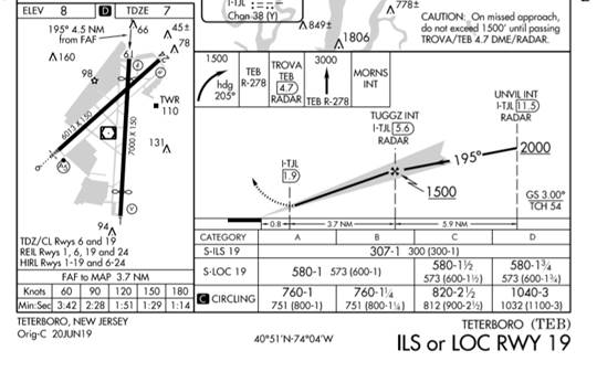
In order to maintain safe clearance from the WABC antenna just west of the Final Approach Course, it’s necessary to continue straight ahead until passing the I-TJL 1.9D MAP before commencing the turn to heading 205. The aircraft is protected in the same way if the pilot flies the ILS 19 to the published DA of 307’.
ARINC 424 FMS coding conventions have indeed created inconsistencies. TERPS & PANS-OPS utilize specific methodologies that are independent of ARINC 424, and mis-matches occasionally occur. Let’s further explore this example using the Garmin 750:
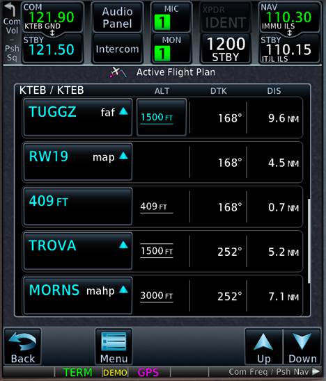
As is typical of ILS approaches, RW19 is coded as the Missed Approach Point, followed by a straight climb to 409’, and then direct to TROVA. Although inconsistent with the published procedure specification of an immediate right turn to heading 205, once the aircraft has passed the RW19 MAP and climbed above 409’ MSL, the FMS should sequence Direct to TROVA as depicted below:
Since the airplane on the Missed Approach is already at least 630’ (LOC Rwy 19 DDA), the CA (Course to Altitude) leg’s 409’ altitude constraint is already satisfied. Therefore, after passing the RW19 MAP waypoint, the FMS should cycle immediately to the second part of the Missed Approach: the DF (Direct to Fix) leg to TROVA. In other words, the flight guidance should initiate a turn to TROVA after passing the RW19 MAP waypoint.
There is indeed an inconsistency between the ARINC 424 coding and the published procedure: The published MAP for the ILS or LOC Rwy 19 approach is not the RW19 threshold waypoint as coded in the NDB (Navigation Data Base). However, this is standard ARINC coding practice for conventional procedures. Although ARINC 424 specifications exist for moving a MAP from the runway threshold, thereby creating a “MAP” waypoint, no such coding was defined for this procedure.
Even considering this inconsistency, TERPS standards have removed the use of the word “immediate” on departures and approaches. When flying the ILS Rwy 19 approach, executing a Missed Approach at the 307’ DA will result in the aircraft reaching 409’ MSL at approximately the point where the RW19 MAP sequences. The FMS and Flight Director would then command a direct-to TROVA leg, making it highly improbable that any loss of obstacle clearance or traffic separation could occur during this interval.
As to the question of CDFA vs. “Dive & Drive”, operational experts fully support CDFA and stabilized approaches as a best practice. However, Flight Procedures in OKC develop NPAs (Non-Precision Approaches) with the intent that the aircraft is level at MDA with enough time to visually acquire the runway environment (approach lights, runway, etc.), and then make a normal descent to the runway. A level segment at MDA gives the pilot the opportunity not afforded by the visibility minima and DDA on a CDFA NPA. In other words, it makes a missed approach more likely. Pick your poison: Risk of unstable approach vs. higher risk of a missed approach. And there are times, like a circling approach where “dive and drive” is appropriate.
Comment:
- Pursuant to AIM 5-4-21, be sure not to initiate the Missed Approach turn prior to the Missed Approach Point.
- Review the Missed Approach legs. Note where the Missed Approach is coded to begin (e.g., RW19, MAP24, etc.). That’s where the FMS will sequence to the coded Missed Approach Segment.
- Note the leg type of the first segment of the Missed Approach. Is it a VA-DF or CA-DF leg? NDB coding does not always match the published procedure.
- CDFA vs. “Dive & Drive” each offer advantages and disadvantages. Determine which is best for the specific operation, and realize that your decision does not alleviate all risks. You may be trading one risk for another.